Raining and 50's as we pull out. Since we were right at the state line, it didn't take us long to cross into Washington!
We passed through Moses Lake. David's comment was did Moses part the Red Sea here? He learned later it was named for a chief.
On I-90 there is a 14 mile stretch where crops are being grown. There are signs about every half mile to tell you what is planted in the fields. In order, here's what we saw:
Alfalfa
Sweet Corn
Field Corn
Potatoes (David saw the rolling irrigation system in some of these fields. He decided they were making mashed potatoes as it rolled over them.)
Timothy Hay
Peas
Grain Corn
Beans
Wheat
Peppermint
Painted Horses
Grapes
The eastern side of Washington is very windy and arid. We stopped a few times for photos. These came from the Columbia River near the Wild Horse Monument:
While enjoying the view from here, we saw this sign:
I did! Didn't see any of them!
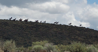
The wild horse monument is on a hill near the river. Look closely, the horses are "running" along the hill.
Here's a closeup:
To get to this bridge from where we were, we had a BIG curve to negotiate:
Up the mountains again. We go through Snoqualmie Pass. It was beautiful, but raining heavily. We knew we had to get off I-90 soon. Sir Garmin of GPS suggested we get off on "Western Australia 18" instead of WA (Washington) 18. The voice on Sir Garmin is Lee from Australia!
We're in Graham, WA for a few days. If it wasn't raining, we should be able to see Mt. Rainier from our campsite. Only problem is, I'm afraid to look out the windows. Seems I booked us into an "Adult" RV Park. There is also a sign saying NO PHOTOS ALLOWED in the campground. Thankfully it's raining and we can't see anyone! I think I'll wear a blindfold over my sunglasses.
See ya down the road!
Jenny :)
Thursday, June 10, 2010
Subscribe to:
Post Comments (Atom)


No comments:
Post a Comment